Case Studies
Our software, data and expertise deliver solutions for location based business challenges
![]()
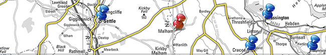
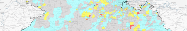
NHS Healthcare Trust: choosing clinic location by travel time
An NHS Healthcare Trust approached us to assist them in a project to intelligently plan the location of their outpatient clinics based upon travel times. Here is how we helped them to simplify and rationalise the process.

![]()
The RAF Benevolent Fund: helping more people with national understanding
The Royal Air Force Benevolent Fund came to us needing to gain a better understanding of the national demand for their services in order to allocate resources effectively and predict future requirements.

![]()
ASP Hair use MapVision to connect clients with their closest distributor
International Hair Cosmetics Limited are a global name in haircare products. Since 2012 their sales support team have been using our solutions to make it as easy as possible for their UK clients to source ASP Hair branded products from the most conveniently located distributor.

Finding the closest distributor in a complex UK-wide network.
![]()
Northamptonshire County Council use P2 to better target their services
Northamptonshire County Council approached us looking for a geodemographic profiling solution to help them to improve service provision and, most importantly, the health and wellbeing of the population of Northamptonshire. We suggested P2 People & Places, our own geodemographic profiling data.

![]()
Stuart Todd Associates simplify town planning with MapVision
When the Director of Stuart Todd Associates approached us looking for a cost effective GIS mapping tool able to offer administrative boundaries, drive-time catchments, and simplicity of use; MapVision seemed like the obvious solution.
![]()
![]()
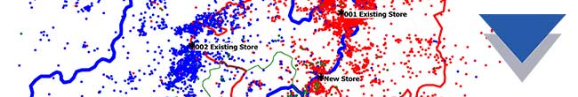
Rationalising and evolving your store network
In an ever-changing marketplace, a business needs to evolve to stay competitive. We’ve written many blogs and case studies about picking the most fruitful location for a new venture using location and demographic data, but what if you have an existing network that you need to review?
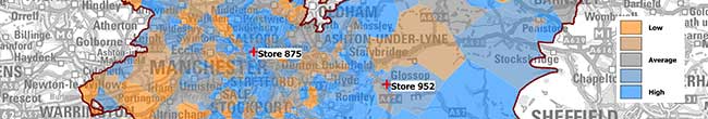
Heat mapping customer density and drive time over a store network map.
![]()
Bespoke interactive mapping of journeys on England’s major road network
Transport Focus, the independent watchdog for transport users, came to us to help develop a survey for Strategic Road Network (SRN) users which measured satisfaction specific to the SRN roads they used. The challenge was to identify where a user had travelled on the SRN whilst keeping the survey intuitive and easy to complete.

Identifying a customer's unique journey and isolating the roads requiring feedback.
![]()
Efficient client contact for Simplyhealth consultants
When Simplyhealth approached us back in 2009, they needed a fast and accurate way to determine the nearest clients within range of their consultants. Our TimeTravel drive time & distance data seemed like a good solution. 10 years later and we are still working together to provide the best possible service to Simplyhealth’s clients.
Sometimes the "closest" consultant isn't the one who can get to you most easily.
![]()
Competitor Analysis - How we helped a client with competitor acquisition
In early 2017, one of our clients of over a decade and a market leader in their industry, approached us about producing a large batch of maps and data, all to the same specification. The maps were to be used to analyse competitor locations as part of a bid to buy a competitor’s network.
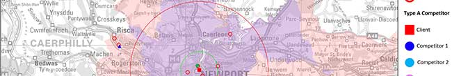
Analysing store catchments and customer behaviour.
![]()
Rexel UK - batch producing maps and site territories
Rexel UK came to Beacon Dodsworth looking to allocate territories to their branches throughout Great Britain and Northern Ireland. Here is how we worked together to maximise the efficiency of each branch in their network.

Allocating territories to branches across the country.
![]()
McGinley use TimeTravel for efficiently planned site visits
McGinley Support Services is one of the UK’s largest specialist recruitment agencies providing the Infrastructure sector of the construction industry with permanent, contract and temporary staff at all levels. They originally came to us wanting a solution to allow them to calculate the time and mileage required on site visits.

Identifying an audience for a venue using demographic and geographical data.
![]()
Promoting excellence in public services with Prospex mapping software
Since 1998 we’ve been working with a not-for-profit body that seeks to improve Local Authority frontline services such as refuse collection, environmental health and housing. During a period of public sector cuts and local authorities running at a deficit, we are delighted that we can help them make such a positive contribution to local services.
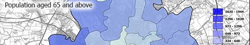
Identifying vulnerable individuals using geographic and census data.
![]()
Prospex GIS helps target the right addresses
Street level mapping and postcode lists help fundraisers keep in touch.
Locating blacklisted addresses improves fundraising efficiency
![]()
Jailhouse Tours use demographic and geographic data to find their audience
Based around existing heritage sites, it was vital for Jailhouse Tours (JHT) to understand the potential audience surrounding their venues in order to accurately target and select a suitable message for their audiences. JHT approached us wanting to know who lived within a reasonable drive distance of their locations.

Identifying an audience for a venue using demographic and geographical data.
![]()
Responsive UK-wide drive times with postcode level accuracy
One of the UK's largest budget hotel chains country approached us. With sites in both rural and urban locations and some towns and cities served by many hotels, the client wanted to make it easy for customers to book the hotel that is most convenient for their plans. Our solution was to use our TimeTravel product to supply the data for an interactive hotel finder on the client’s website.
Where is my nearest accommodation?
![]()
Reliable drive time data improves marketing efficiency
RAC use TimeTravel to enhance customer service.
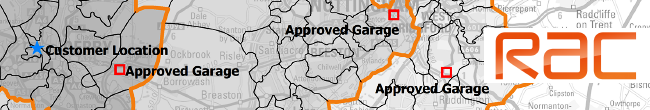
Approved garages near to the customer
![]()
Drive time data delivers accurate mileage claims
Since 2011 we’ve been providing the NHS Shared Business Services (NHS SBS) with a mileage calculation web service that’s efficient, simple to use and accurate.
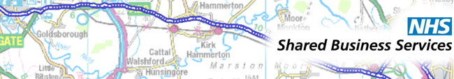
Comprehensive drive time data delivers accurate mileage calculations
![]()
Franchise area mapping & location analysis - GIS software
Using GIS to analyse locations and produce detailed franchise area maps.
Using GIS to analyse locations and produce detailed franchise area maps
![]()
Our mapping consultancy delivers RSAcademics client solution
Our student profiles and modelled data provides valuable insight for education providers.
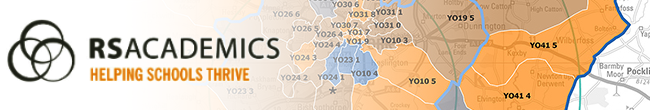
Visualising data in a spatial context highlights patterns, trends and relationships
![]()
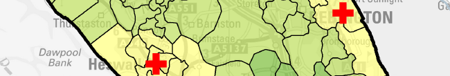
Finding the best locations for businesses - MyHealthcare Clinic
Location analysis delivers the intelligence required for accurate decision making.

Maps and data provide a detailed and precise view of locations
![]()
Customised online travel survey that captures user journeys
Replacing time consuming expensive personal interviews with an efficient online solution.
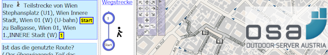
Online journey capture across Austria
![]()
Schedule and order field force visits
Tactical Solutions use Prospex GIS to order visits to over 1600 retail outlets.
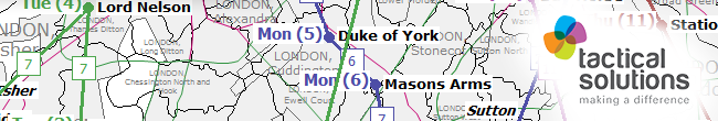
Automatically generating call schedules and routes
![]()
Simply Argan find the right people to get samples
Geodemographic profiling helps target marketing investment.
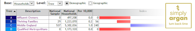
Profiling customers improves marketing efficiency
![]()
Retail analysis finds the best locations for a new enterprise
Using existing retail data to predict market potential in target locations across the south of England.
Retail analysis comparing shop sales with LCF spend
![]()
Major insurer improves underwriting by using TimeTravel data
The London office of a global general insurer, with more than 320 offices worldwide, approached us with a challenge. They wanted to take an innovative approach to assessing fire risk by looking at the distance of their clients from their nearest fire station. What can we say, we love a challenge.
Drive time analysis in risk assessment
![]()
Planning inquiry use Beacon Dodsworth as experts
Combining data analysis, mapping and visualisation for accurate testimony.

Coverage of proposed location by existing services
![]()
Using Prospex GIS to define store delivery areas
A nationwide retailer wanted to showcase local stock on a new website. They came to us to create realistic local catchments that matched each customer to their closest store. This how we helped each customer view their closest store’s stock online and make delivery as efficient as possible…
Planning for efficient deliveries
![]()
Customer analysis finds new locations
Vision Express use Prospex and P² People & Places geodemographics for essential planning.
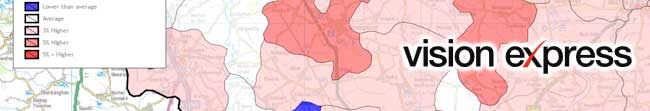
Customer analysis of retail data
 Sign up for our newsletter
Use of cookies
The Beacon Dodsworth site uses cookies to improve your user experience and to provide analysis of how our site is used.
Your continued use of this site is taken as implied consent to receive cookies from us and our analytics partners.