Postcode coordinates and locations
Accurate postcode coordinates from the Office for National Statistics
A series of data products for geolocation and analysis. Made from the National Statistics Postcode Directory (NSPD) issued by the Office for National Statistics (ONS)
PostView postcode point data
Whether you need a postcode point on your own map, a place name associated with a postcode or even all the postcodes in your local authority, PostView data products have the answer.
- PostView Points: geolocated postcode points with optional additional data
- PostView Places: geolocated places with postcode and administrative data
- PostView Streets: street name to postcode and location lookups
- PostView Label Points: labelling points or postcode weighted coordinates for every postcode sector
NSPD is the definitive postcode location dataset. The data is updated regularly and contains records for all current and terminated postcodes. Beacon Dodsworth process the NSPD postcodes for use in a wide range of data and demographic products.
Call 01904 701020, complete Contact Form or Sign Up
PostView postcode points
![]()
PostView Points: postcode coordinates, dots on a map
- PostView Points Simple: Postcodes and coordinates
- PostView Points Complex: Simple plus settlement, locality and county
- PostView Points Advanced: Complex integrated with administrative boundary data
PostView Points Simple
Accurate coordinate data for every postcode in east and north or longitude and latitude.
PostView Points Complex
Add settlement, locality and county fields to postcode coordinates. This means you can identify the nearest settlement to a specific postcode or even all the postcodes within a target county.
PostView Points Advanced
A customisable dataset that adds extra fields to PostView Points Complex to answer your requirements. Locate your audience in any administrative boundary. This can range from which postcodes are within a parliamentary constituency to which health area is responsible for patients.
| Data | Example | Simple | Complex | Advanced |
|---|---|---|---|---|
| Postcode | YO23 2BD | Y | Y | Y |
| East /North | 458885/0448101 | Y | Y | Y |
| Longitude / Latitude | -1.10477/53.9257 | Y | Y | Y |
| Settlement | York | - | Y | Y |
| Locality | Bishopthorpe | - | Y | Y |
| County | York | - | Y | Y |
| Output Area | E00067334 | - | - | O |
| Lower Super Output Area | E01013340 | - | - | O |
| Ward | Bishopthorpe | - | - | O |
| Local Authority | York | - | - | O |
| Local Education Authority | York | - | - | O |
| Parliamentary Constituency | York Outer | - | - | O |
| European Electoral Region | Yorkshire and the Humber | - | - | O |
| Primary Care Trust | North Yorkshire | - | - | O |
| Strategic Health Authority | Yorkshire and the Humber | - | - | O |
| Government Office Region | Yorkshire and the Humber | - | - | O |
| Fire | North Yorkshire | - | - | O |
| Police | North Yorkshire | - | - | O |
| Ambulance | Yorkshire | - | - | O |
| ISBA | Yorkshire | - | - | O |
| Y data available, O data optional, - data not available | ||||
![]()
Locational data beyond a simple Postcode co-ordinate
- PostView Places: The most important place name in a sector
- PostView Places Advanced: The most important placename in a postcode
- PostView Streets: The nearest street to a postcode
- PostView Label Points: Label points for postcode sectors
Identify postal and administrative data linked to a named location
PostView Places gives you a record for each place name showing: postcode sector name, grid reference and county. PostView Places Advanced provides the same detail, but provides a more accurate full postcode name.
Identify the nearest street to a postcode or settlement
PostView Streets matches a street name to return a record detailing: full postcode, postcode sector, settlement, locality and co-ordinate.
Locate postcode sectors
The PostView Label Points product supplies you two options, either a coordinate located to give neat labelling, or a postcode weighted coordinate reflecting more densely populated areas.
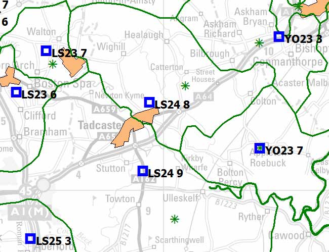
Green asterisk: Label point. Blue square: Weighted centroid
 Sign up for our newsletter
Use of cookies
The Beacon Dodsworth site uses cookies to improve your user experience and to provide analysis of how our site is used.
Your continued use of this site is taken as implied consent to receive cookies from us and our analytics partners.