The power of postcode sectors
We all know our postcode, or at least we should do. It is an integral part of our address, making routing our deliveries more efficient, and guiding SatNavs. Part of the power of the postcode comes because individual, full postcodes are the building blocks of larger units: postcode sectors, districts, and areas. Together, they form a neat hierarchy - see our postcode blog for more on this – and provide different balances of detail and scale to suit any level of consumer geographic analysis.
Postcode sectors vs. full postcodes: scale vs. detail
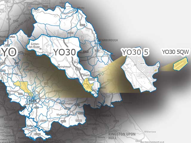
A full postcode (e.g. YO23 2BD), also known as a unit postcode, is a collection of addresses, usually on a single street, normally forming a natural group or cluster. Typically, our postcode is shared by a few neighbours (on average about 15). With more than 1.7 million postcode units they are great for pinpointing deliveries and journey destinations but quickly overwhelm any larger-scale geographic analysis.
A postcode sector is represented by the first half of a postcode and the first number of the second half (e.g. YO23 2). On average a sector is made up of 180 postcodes; the most being 390, the least is 1.
Due to its size, the postcode sector is the most practical reporting unit for geographic or geodemographic analysis. It is small enough to give geographical detail but large enough to show some homogeneous behaviour and reveal local patterns.
The challenge of defining postcode sector boundaries
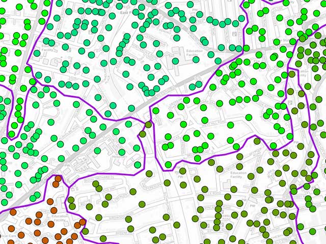
Well defined boundaries are vital for meaningful reporting. However, as postcode sectors are aggregations of individual postcode points, defining their boundaries is a challenge. There are several complicating factors:
Density of postcodes within a sector
Where postcodes meet very closely, the boundary has to "weave" between two dense sets of points. At the other extreme, where postcodes are very spread-out, imposing a boundary can seem very arbitrary.
Outlying postcodes
A peril of aggregating points into areas is that you will encounter lone postcodes residing in another sector. In these cases, do you have a postcode island or do you find a way to join it to its parent sector as a kind of postcode peninsular. Some postcode sectors also contain new postcodes that have not been assigned coordinates, making plotting them even more challenging.
Industrial vs consumer postcode sectors
"Large users", usually businesses, provide their own forms of complexity. A large complex, with its own postcode may exist inside the boundary of a residential postcode sector. Alternatively, their postcode may only be loosely related to their nominal sector. Very large business premises may be entirely stand-alone with no equivalent residential postcodes sharing their sector. To give a sense of scale to this problem; of 11,235 postcode sectors (as of September 2022), only 9,571 are classed as residential areas.
The perils of island living
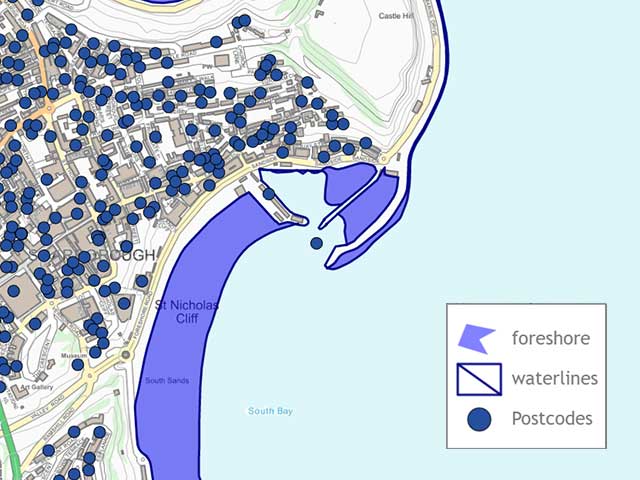
As an island nation, the British coast forms a natural boundary for some sectors, but which coastline should we use? There are several suppliers of mapping information whose coastlines differ slightly. There is not always a single coastline from any one supplier but variations dependent upon tides - high, low, and mean average water levels. Sometimes details such as piers and docks appear in detail, sometimes not.
We have “stitched” on the detailed Ordnance Survey Open Data Boundary Line coastline to our own data, which is Mean Low Water. This has the advantage of overlaying well with other OS background maps and it can be generalised (reproduced at a lower resolution, with fewer “wriggles”) for more rapid display (e.g., for online mapping).
Of course, the UK is not just a single island. The Channel Islands: Jersey (JE) Guernsey (GY), and the Isle of Man (IM) have a postcode system but full postcode co-ordinates are not published. We have created sectors from locality information and royalty-free maps. For mapping convenience we often transpose the Channel Islands north in the English Channel.
Change over time
Postcode sectors regularly change as they aggregate the many changes to the postcode network within them:
- improved accuracy of co-ordinates,
- new builds,
- demolition,
- reassignment - when a postcode is altered by Royal Mail,
- reuse - when an "old" postcode is brought back into use at a different location.
Sometimes there are not enough available postcodes for a sector. Because of the naming convention where the last two letters identify the postcode, there are only 400 available distinct postcodes (the letters C, I, K, M, O and V are not used because of easy confusion with other letters for automatic sorters and humans). In this case a new postcode sector is created. Sometimes the Royal Mail split a sector into two or more new ones.
To put the scale of change into context, the first version of PostView, our postcode sector dataset, created more than 20 years ago, had 8,400 postcode sectors; It now has 11,235 (as of September 2022).
We are always happy to talk about helping you use postcode geography in your business analysis. Why not email info@beacon-dodsworth.co.uk and see how we can help your business.