Mapping efficient sales territories
Whether you are in the fortunate position of expanding your sales team to meet demand, making your existing sales catchments more efficient or identifying hunting grounds for a new business; territory planning needs some serious consideration. After all, a small team with efficiently planned sales catchments is more effective than a larger team that spends all of their time on the road travelling to smaller or less valuable clients - and with a far higher profit margin!
We have been working with Geographic Information Systems (GIS), mapping, demographic and travel data for a long time, and have become specialists in territory mapping. So we’d like to share a few tips on best practice if you are about to define sales catchments for your team, or embark on territory review.

How to define sales territories
The two main ways of defining territories for mapping is by size or volume. Both of those factors can be measured in different ways, each with its own pros and cons. Ideally, you want to combine both methods and balance the size of the territory with the amount of work it is likely to be, or value it will provide. However, before you even get to this decision there are fundamental questions to answer that will set a foundation for the whole project:
- Where do your territories start? This will be defined by your existing organisational setup. For example, do your agents work from home or do you have a local office network to form the central point of each territory? Do you have the capacity to recruit or open new branches as a result of this territory and customer analysis, or are you limited to an existing network.
- Who are your customers? This will help to define the outer boundaries of each territory. Setting completely bespoke boundaries might work for you, but working to an existing network can reduce work over the long-term. Postcode boundaries are very robust for B2C and private sector sales territory maps. On the other hand if your client base is public sector, you might want to emulate their administrative geography, whether that is CCG boundaries, local authority, or Police and Fire Authority Boundaries.
- What scale are you working at? Most fundamentally, are you selling to the whole country or do you have a regional focus? Also consider how granular to be in your mapping. If you have a large sales team (50+ individuals) then planning to a postcode sector level (eg. YO23 2) would provide the greatest level of detail, but would be unnecessary for a smaller team. On the other hand, postcode areas (eg. YO) are too unwieldy for most people, so most of our clients tend to work to postcode district (eg. YO23) level for a balance between detail and ease-of-management.
Defining territories by size
The most obvious way to define a sales catchment is by size. But how are you going to define that size?
- Total size is the most basic way to define territories. After all, why not just split the country into equal chunks to match the number of sales representatives you have? Well, we would caution against setting one fixed size across the network as, depending on your product, a 100 square mile territory in south-east England, is a very different proposition to the same area in the Highlands of Scotland.
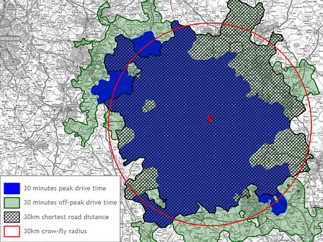
- Travel distance can very effectively generate serviceable areas for each representative, but you need to be aware of certain stumbling blocks. Crow fly (or straight-line) distances from an origin point will not allow for road network, river/sea crossings and other geographical factors. Even when measuring travel distance based on the road network, keep in mind that 100 miles on a motorway isn’t a fair comparison to 100 miles on small country roads or in peak-time urban traffic.
- Travel time is a better general measure of a territory than travel distance. You can ensure that all clients are within a practical distance of each member of your field team. It removes a lot of the bias that a top-down map view can create. Ensure that your travel time data allows for vehicle type and time of journey. For example, your HGV delivery fleet and car-driving sales team will need very different catchment areas and those “reasonable” drive times may look very different during peak hours.
Defining territories by customer count or value
Looking at the contents of a territory rather than its size is another good approach to balancing sales catchments.
- Client quantity: The easiest approach to take if you want to give some consideration to balancing the client portfolio for each agent. Most respectable mapping platforms are able to give a count of points in an area without having to resort to a full desktop GIS.
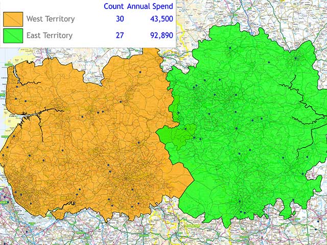
- Existing client value: A more advanced approach is to balance the value of your clients across the sales team. This is especially useful if there is strong competition between your reps, or performance related remuneration which might otherwise cause disputes. This kind of multi-field comparison is more advanced than just counting each client postcode, so will involve either greater manual intervention with a standard mapping tool or an advanced geographic data system.
- Potential client value / geodemographic profiling: A very useful approach for new businesses and those looking to expand their distribution or client base. An established business could analyse their best customers and identify their most profitable demographic profile. This could then be mapped nationally, hot spots of potential business identified, then allocated to territories in a similar way to existing client value. A new business without a sales database could select an ideal demographic model that would shop for their product and then apply this to their territory planning project.
Balancing the complexity and cost of territory management
Ideally you would balance territory size with customer quantity and value. The more factors you include in your plan, the more efficiently your team will work but the more complex the calculations become.
- The cheapest way to create a sales network plan: A basic radius-based territory map is the easiest to create in most free mapping packages. Though better than nothing, this will do very little to create an effective sales network.
- The most cost-effective territory plan for a small business: A way to combine a few of the above factors into a sales plan is to use a more capable data mapping system and invest some time overlaying different map layers to working out your own ideal territories. Ideally use a more in-depth mapping system that incorporates drive-time tools such as MapVision to avoid misleading crow-fly radii to add an element of real-world effectiveness to the plan.
- Create a one-off territory plan or review your current sales network: consultancy is probably the best solution for an organisation looking to intermittently review their sales team catchments. Using us as an example, you would benefit from our full range of GIS tools, along with any journey time or geodemographic data without having to invest in software or training. Even if you review your network annually, this is still likely to be the most cost-effective approach.
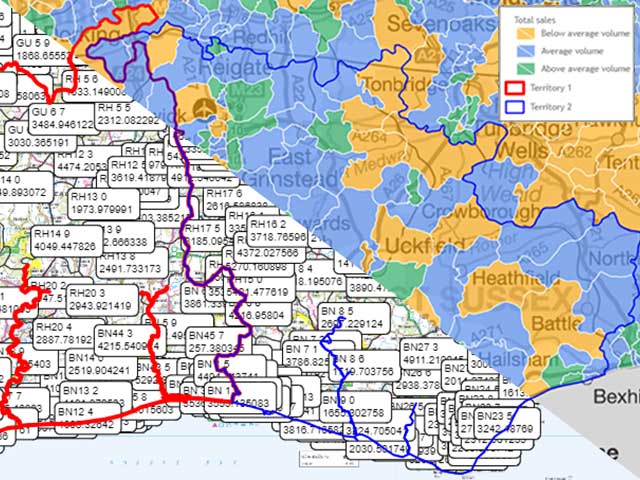
- Regular territory reviews for a larger sales team: would best be done using an in-house GIS. Using our own Prospex GIS as an example, the territory builder function brings together multiple factors and builds sales areas out from a starting point. This process will then stop once it has reached your defined boundary, whether that is a fixed distance or travel time from a starting point, a fixed customer count or value, postcode boundary or another agent’s territory. If you have a larger team, high staff turnover amongst sales staff, or a dramatically changing customer base, then having this location intelligence tool at your disposal will pay for itself very quickly.
Other business mapping considerations
Visualise numbers rather than relying on labels
A good territory plan balances a lot of data. Try to display all of this as figures on a map, either as labels, a key, or both and you will overwhelm it. Make sure you use colours and patterns to enrich a map and help to convey core data. If you have to include granular detail, add it as pop-ups that can be clicked on within an interactive map when a user wants to see it.
Map for multiple audiences
We’ve talked throughout about a territory map but it is important to remember the final deliverable isn’t a single map. You are likely to need:
- An interactive sales map for day-to-day working by your sales consultants.
- A head office network wall map, printed out at a large scale for managers and operators to refer to.
- An interactive web map with simplified data so potential clients can find their closest rep.
- A simplified network map as a flat high-resolution image to include in print brochures and sales collateral.
This means that you’ll need a territory mapping solution that lets you quickly apply themes to data. Themes allow you to switch between maps at the tick of a box and share them via multiple media such as i-frames, web-sized flat images or high resolution images for print.
Keep your territories efficient and up-to-date
Maintaining territories is as important as creating them. Team members join, leave, and move house or office. Your customer base is constantly changing. Even the basic geographies that underpin the mapping change - for example Royal Mail introduced 9 new postcode sectors in 2021 - whilst the road network and traffic patterns constantly evolve. How regularly you review territories will depend on a number of factors but the point to emphasise is that it needs to be “regular”. Just because your sales team and branch network haven’t changed for 15 years, doesn’t mean the world has stood still around you.