New features in MapVision
MapVision is a living product, that means it is constantly evolving to meet our clients' needs. We actively engage with our clients to understand how they are using the software and target our development to make it work better for them. This is why we offer MapVision as a subscription product, to ensure that we can keep it up-to-date, reliable, and tailored to your needs.
Being web-based, you only need to refresh your browser window to benefit from MapVision updates – no downloads, tedious updates, or frustrating progress bars.
Try MapVision for free
3 day free trial for business users - no payment details required.
(Regular subscriptions start from £395.)
Submit your details below and we'll email you a link to the trial.
Here are the most recent major updates delivered for MapVision. For the full list, including minor updates, optimisation, and fixes, go to the new features tab in the MapVision account section.
New data: rasters, census and healthcare boundaries – Winter 2022-23

2022 was a pivotal year for the UK’s infrastructure with the 2021 Census results starting to be released using new administrative boundaries, and the new Integrated Care System (ICS) coming into effect in England. We’ve updated MapVision to reflect the latest geographies, including:
- Administrative boundaries to fit forthcoming census data releases: Output Area (OA), Lower Super Output Area (LSOA) and Middle Super Output Area (MSOA)
- Healthcare boundaries for the new Integrated Care Systems (ICS) / Integrated Care Boards (ICB) for England
- The two largest scale background maps have been updated to the latest Ordnance Survey (OS) OpenLocal and VectorMapDistrict
New module: call scheduler – Autumn 2022
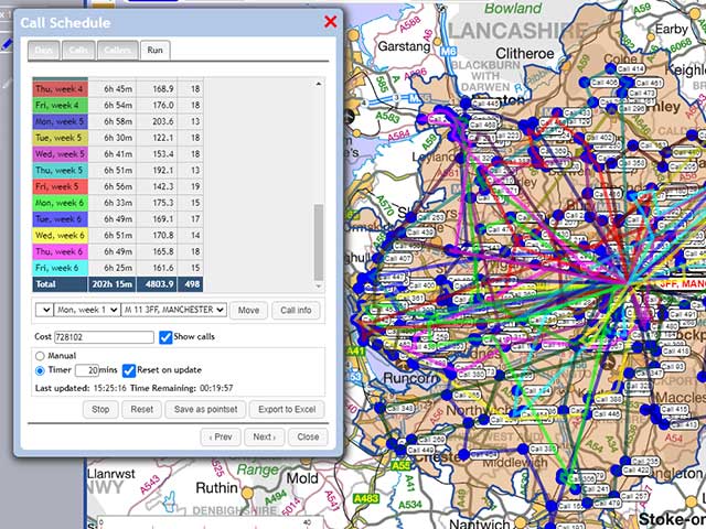
This new module calculates the most efficient visit schedule from realistic travel times, based on our own TimeTravel journey time / distance data. The scheduler allows you to:
- Define a working time and maximum number of calls each day to suit your field team
- Specify visit time or day for each destination, or set a default across your client list
- Set the length of working week to suit either clients or visiting agents
- Create a visual colour-coded point map for your field team or download an excel call list to work from
New module: profiler & targetter – Summer 2022
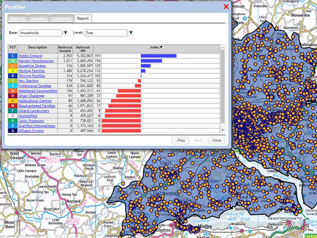
Learn more about your sales catchments or customer groups with the new demographic profiler. Once you have identified key demographic groups, use the new targetter to direct your campaigns, or identify sites that have a high percentage of your desired audience:
- Analyse the postcodes within your data to look for the best (or worst) areas based on the categories within our P² People & Places geodemographic profiling data
- Any data with a geographic key, or polygon areas can be indexed against nationwide averages
- Define a catchment, select the demographic groups you are interested in, and create a list of the Postcode Sectors ranked by penetration and indexed against the national average
- Download this ranked and indexed data as a list of target postcode sectors
New vector map: OS Open Zoomstack – Spring 2022

OS Open Zoomstack is a vector map of the whole of Great Britain created by Ordnance Survey. Available to all MapVision users, just add it to one of your mapping projects from the free data library and add depth to your most detailed mapping projects:
- Rural mapping: Display landscape contours, greenspace, and foreshore in detail on your maps
- Urban planning: Show urban extent, building areas, or even individual building outlines
- Branding: As a vector file, each element can be themed to match your project or brand
- Customisation: Find the perfect balance between simplicity and information by activating as few or as many geographical features as you need
Would you like to know more?
If you would like to know more about any of these features please Get in touch for a demonstration. Don't forget, whatever you are using MapVision for, help is just a click away on web chat or via the "help" button in the top right of the MapVision interface. Subscribers to our free e-newsletter receive quarterly updates on the latest MapVision features – you can sign up for our newsletter in the footer bar below
Try MapVision for free
3 day free trial for business users - no payment details required.
(Regular subscriptions start from £395.)
Submit your details below and we'll email you a link to the trial.